Prototyping Safer Streets
Demonstration Projects in Burlington, VT
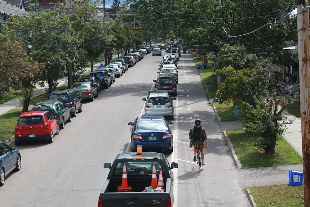
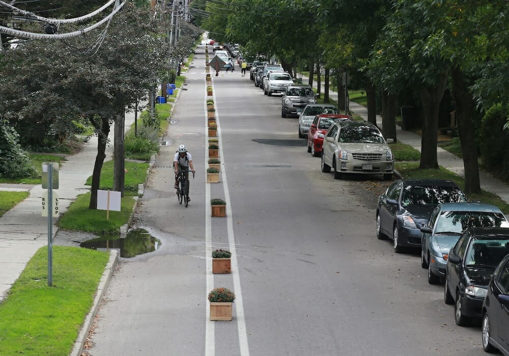
A cyclist coasts down the new parking-protected bike lane, a demonstration project in Burlington, VT.
By Julie Flynn, Project Manager, Street Plans Collaborative; Edited by Mike Lydon, Principal, Street Plans Collaborative. Images courtesy of Street Plans Collaborative and Julie Campoli
Imagine standing in the middle of New York’s Times Square in 2008 — you’re surrounded by snarling traffic with car horns beeping and yellow taxicabs zooming by at lightning speed. It’s a space ruled by cars, a dangerous one for pedestrians and cyclists alike. If you told someone back then that in just a few short years Times Square would be permanently closed to vehicular traffic and be a haven for pedestrians enjoying outdoor seating and street performers, she’d say you were crazy.
But what seemed physically and politically impossible actually happened. How? Rather than debate and study the idea behind closed doors for decades, the New York City Department of Transportation (NYCDOT) started small, with a short intervention to improve traffic patterns and increase pedestrian safety. In 2009, through their Green Light for Midtown project, they worked with neighborhood partners to close Broadway between 42nd and 47th streets to create a pop-up plaza for one weekend using traffic barricades and inexpensive folding chairs. Contrary to the concerns of some, the temporary street closure did not cause a transportation system meltdown. Following the successful weekend-long demonstration project, NYCDOT used slightly more durable, but still low-cost and temporary, materials to create a summer-long pilot plaza at the site.
The agency studied the impact of the plaza on pedestrian safety, public life, traffic, and local business revenue. They found 2-17% improvements to trip speeds across multiple routes. Injuries to motorists and passengers in the project area declined 63% and pedestrian injuries fell by 35% (1). After analyzing impacts and refining the design incrementally, NYCDOT moved to permanently close off Time Square to cars with a full build-out of the pedestrian plaza — transforming the area from a site of constant traffic congestion and frequent pedestrian injuries into an iconic and much-loved public space.
Design sends the strongest signal about how to move through a space.
Tactical Urbanism
The transformation of Times Square represents a new and much needed change in the approach to improving our streets. Over 30,000 people are killed in traffic crashes in the United States every year (2). Design sends the strongest signal about how to move through a space, and unfortunately many city streets are designed with little other goal than to move vehicles as quickly as possible. The National Association of City Transportation Officials documents a strong correlation “between higher speeds, crash risk, and the severity of injuries” (3). While enforcement and posted speed limits play a role in controlling speed, proactively designing streets to reduce speeds “may be the single most consequential intervention in reducing pedestrian injury and fatality” (4). Thus, as more people in the US are moving to urban places and walking and biking to get around, cities are working to design streets to not only move cars, but also to make it safe and convenient for people of all ages and abilities to walk, bike, or take transit.
Unfortunately, timelines for projects often feel maddeningly slow. Politics, budgets, permits, and competing interests get in the way, sometimes halting a project before a conceptual design can even be proposed.
For a parent who wants their child to be able to walk or bike to school, waiting 5 to 10 years for a streetscape upgrade with a protected bike lane is exasperating. This is why people often throw up their hands and give up on the urban planning process — it’s hard to accept the slow pace and lack of transparency around implementing capital improvements to our roadways.
More often than not it’s the unknowns — the unknown impacts resulting from a change — that hold projects back. In NYCDOT’s Times Square project, cab drivers thought the changes would cause traffic jams and local business owners thought retails sales would decline. The iterative approach NYCDOT applied allowed the agency to gather data and test those unknowns — neither scenario played out.
While large-scale efforts do have their place, cities around the world are increasingly looking to small, incremental projects as an important tool for advancing long-term goals related to making changes to the streetscape. Sometimes sanctioned, sometimes not, this approach is often referred to as Tactical Urbanism: a city, organization, and/or citizen-led approach to neighborhood building using short-term, low-cost, and scalable interventions intended to catalyze long-term change.
Tactical Urbanism is an approach to city-making that embraces an iterative approach. The approach might involve short- term demonstration projects, like pop-up bike lanes, guerrilla crosswalks, or play streets. At a longer time scale, Tactical Urbanism might involve pilot or interim-design projects that last months or years. Examples include curb extensions created with paint and bollards, rapid-implementation of protected bike lanes using low-cost materials, or NYCDOT’s second plaza iteration, using paint, planters, and movable furniture.
Though the Tactical Urbanism approach doesn’t always start with a weekend-long pop- up, many communities find that a small step is the right place to start. Even if a project lasts merely a few days, it can be a valuable way to spark real conversation about street design changes and help people imagine something they didn’t know was possible. Take protected bicycle lanes for example. Though they are popular in many European cities, most people in the United States have never seen or experienced one. In the past 3 years, a growing number of advocacy organizations and community groups across the country have created pop-up, protected bike lanes to educate decision-makers and residents about their many benefits. Riders on protected lanes are 50% safer, says research published in the American Journal of Public Health (5). And a recent study from Portland State University showed that protected bike lanes increase bicycle ridership up to 171% on some streets, and that 10-21% of riders in these lanes switched to cycling because of the safer route (6). That means less cars, less traffic, less pollution, plus healthier lifestyles.
Burlington, VT
Burlington, VT is consistently rated as one of the most livable and creative small cities in America. With access to forest, mountains, lakes, and the Winooski River, Burlington’s appeal for outdoor recreation is hard to match. The city has a walkable downtown with well-preserved historic architecture, and compact development patterns that make it inherently conducive to travel on foot and by bike.
However, like many communities across the country, Burlington is experiencing growing demand for safer streets with better walking and biking opportunities for all. The City of Burlington’s vision for improving its streets’ walkability and bikeability was well articulated in planning documents dating back almost a decade, but the city still had no dedicated plan for defining strategy and setting priorities for active transportation investments.
To help Burlington transform itself into place where walking and biking are viable, enjoyable transportation options for all, city leaders launched their first-ever active transportation master planning process. The effort was organized by Burlington’s Department of Public Works (DPW), which hired Vermont-based engineering firm, Dubois & King, as well as our team at Street Plans Collaborative to lead the project.
“With this plan, the City of Burlington aimed to turn our well-established community visions for a walkable and bikeable city into specific, actionable projects that are prioritized by the community,” said Nicole Losch, Transportation Planner with the City of Burlington Department of Public Works. “The city’s goal is to increase the number of people walking and biking no matter their age, gender or level of ability. To do this, we needed a plan that would present specific projects for rapid implementation to make walking and biking safe, comfortable, and convenient for all, and we were interested in using innovative and non-traditional public involvement techniques as part of the process.”
The Street Plans Collaborative kicked off the project in July of 2015 with a series of public events designed to help the team understand existing conditions and identify community priorities. Through walking and biking tours, dozens of local residents helped the project team identify challenges and opportunities throughout the city. An evening public workshop allowed residents to introduce their top priority project and then rate each other’s ideas, using crowd sourcing to elevate initial priorities. Street Plans Collaborative also launched a dedicated project website with an interactive map that allowed people to submit geo-tagged comments and suggest project ideas.
This initial public outreach revealed a handful of streets that were major pain points for people walking and biking — it’s no surprise that these streets also aligned with high incidences of traffic crashes and injuries. Burlington residents and advocates wanted a bold plan to catapult the city into position as a leader in pedestrian and cycling transportation alongside leading cities like Portland, OR; Minneapolis, MN, and Boulder, CO. They wanted the plan to include projects and policies that would make walking and biking safe, comfortable, and convenient not just for the spandex-clad MAMILs (Middle- Aged-Men-in Lycra), but for people of all ages, genders, and abilities. And, they wanted to see action fast — many expressed fear that Burlington was stuck in a cycle of too much planning and not enough action, a situation sometimes referred to as “analysis paralysis.” Residents had a vision and wanted change now.
All public projects have trade-offs. On compact urban streets, like those found in Burlington, adding new bicycle or pedestrian amenities might require narrowing lanes or eliminating curbside parking in certain areas. Despite a growing body of data demonstrating the economic and health benefits of better pedestrian and bicycling infrastructure, such design changes are not always an easy sell to parties who are accustomed to existing street designs. Emergency service providers rely on wide lanes and local shop owners often worry that fewer parking spaces will negatively impact their sales.
If we were going to create a bold plan, the typical public engagement framework of analysis and public meetings would not be enough. We had to involve a larger, more diverse pool of people to push the discussion out of the public meeting room and onto the street.
Street Plans Collaborative worked with DPW and local advocacy group, Local Motion, to design two multi-component demonstration projects that could be installed temporarily in neighborhoods on either end of the city. The projects were intended to expand the conversation about active transportation and allow residents, business owners, and city agencies to create, physically experience, and react to new types of pedestrian and bicycle infrastructure. To maximize public input and impact, the projects were timed to coincide with two popular local events, both of which were expected to draw thousands of people over the course of one weekend.
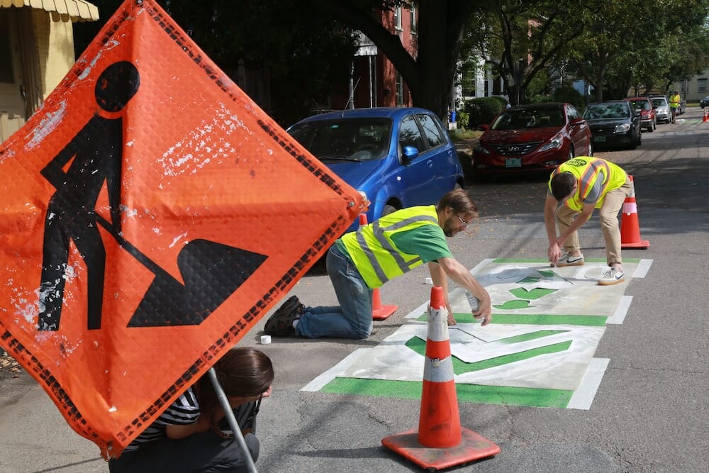
The first project, in the South End of the city, was focused on enhancing pedestrian safety and comfort. Next to a highly-trafficked food and entertainment hub with little public space, we envisioned a new parklet, repurposing an existing parking space and turning it into a curbside public space for sitting and socializing. To reduce street crossing distances for pedestrians at the adjacent intersection, we created a curb extension with a decorative mural covering the pavement.
The second project was planned to coincide with Burlington’s 2nd Open Streets event in the North End of the City. Sometimes called “Ciclovias,” Open Streets events temporarily close miles of streets to cars so that people may use them for dancing, playing, socializing, walking, or biking. We knew that Burlington’s Open Streets event would draw thousands of people interested in walking, biking and making their community a better place, so adjacent to the route we planned to demonstrate three new bikeway types: a planter protected bike lane, a neighborhood greenway, and Burlington’s first parking-protected bike lane. Event attendees would have the opportunity to ride or walk around the demonstration projects, taking a “tour” of some of the new street designs that might be proposed in the master plan.
With our vision and design drawings in place, DuBois & King drew up traffic control plans so that volunteers could safely install all four projects in the street. DPW circulated the project concepts and traffic control plans to key partner agencies, including the transit agency and fire and police departments.
With a mere $4,000 budget for materials across the two projects, Local Motion took the lead in sourcing as many donated and borrowed materials as possible. Community partners loaned the project team brooms and other equipment to clean and prep the sites, as well as cinder blocks and plywood to build benches. A local nursery even lent 100 pots of blooming mums to fill the temporary planter boxes required to create the planter-protected bicycle lane. DPW loaned the team its bicycle marking stencil, as well as the signs needed to implement the traffic control plan. In the end our funding was used only to purchase items that could not be borrowed, such as traffic control tape and paint.
After about one month of planning, the big weekend finally arrived. With the help of about a dozen volunteers, we set to work Friday morning installing the first project – the parklet and curb extensions in the South End. We used tape to mark out the stripes in our parklet and curb extension murals, and got to work painting. Once the paint was dry and cones and planters in place, we set to work creating seating in the parklet area from hay bales and homemade benches crafted from cinder blocks and plywood. We completed the setup just as the large art walk event planned in the neighborhood began to draw an audience. We set one finished bench down and within minutes it was occupied. We didn’t have room to move it or tweak the placement of seating the rest of the night – the bench was never empty again!
With the successful parklet complete we caught a few hours of sleep before the 5:00am curtain call set for the installation of our second project – the three bikeway projects in the North End. We began with the most complicated of the three bikeway types, the parking-protected bike lane. Sleepy volunteers began arriving, and to our delight, we found that the vast majority of people had obeyed the curbside parking ban we put in place the day before – the Police Department removed the two cars parked in our bike lane area, and we set to work cleaning the street and placing the traffic tape in place.
Tactical Urbanism Project Uses
Municipal authorities, organizations, and everyday citizens use Tactical Urbanism as a tool to:
-
Deepen their understanding of local user’s needs at various scales
-
Draw attention to perceived shortcomings in policy and physical design
-
Widen public engagement
-
Tests aspects of a project or plan before making large political or financial investments
-
Expedite project implementation
-
Gather data from the real-world use of streets and other public spaces
-
Encourage people to work together in new ways
-
Strengthen relationships between residents, non-profits, local businesses, and government agencies
Immediately following the installation of the first few parking spaces marked to out delineate the parking-protected bike lane, it became clear that adjustments were needed. Sightlines for cars turning into driveways were too limited, and the overall number of parking spaces in each section needed to be reduced. With input from engineers at DuBois & King, the team adjusted the geometry on the spot by simply pulling up traffic tape and re-marking spots to provide more space at each driveway.
Once the parking-protected bike lane was in place we moved on to the other two streets, painting green super sharrows — large graphics on the street — in place for the neighborhood greenway, and finally, positioning planters in our planter-protected lane.
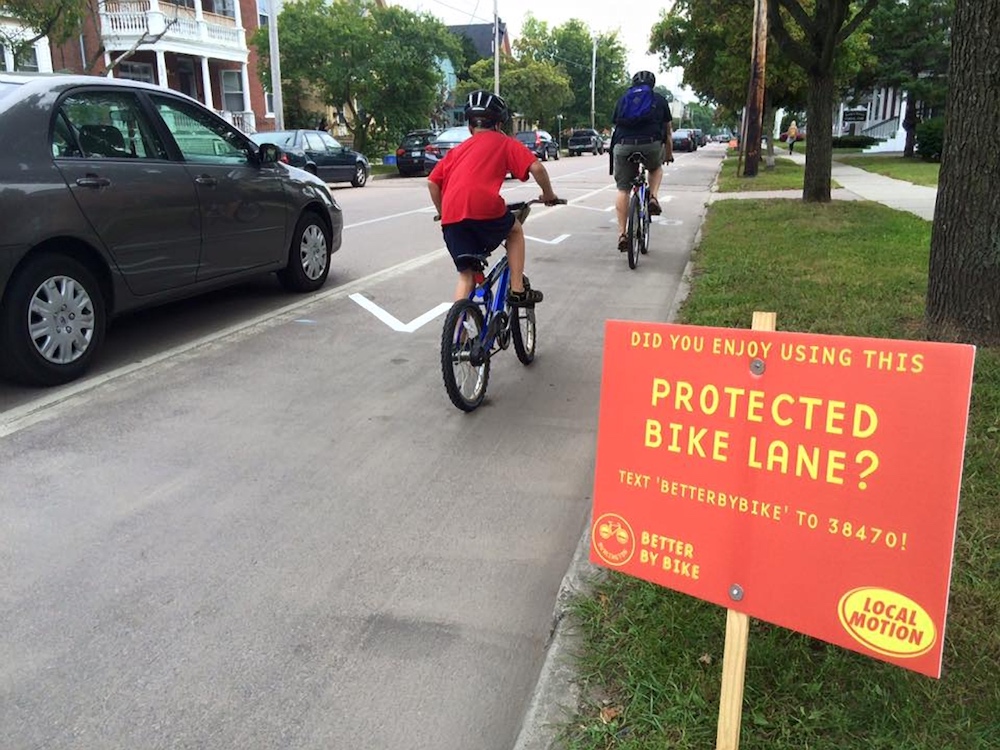
While the planter-protected bike lane and neighborhood greenway seemed clear enough to most people biking through, the parking-protected bike lane was perplexing to some. We watched as the first few cyclists approached the street and, thinking the cars were floated off the curb for an event of some kind, they stuck to the middle of the street and shared the road with vehicles. A few volunteers coaxed people into the parking-protected bike lane, something many had never seen or experienced before. A few people stopped riding to remark at the novelty of the idea – after riding down the lane themselves, they clearly saw the efficiency of the design, allowing parking to remain, and simply using it as a buffer between the bike and vehicle lanes. By Saturday afternoon, we saw people confidently riding their bikes down the parking-protected lane; some even felt confident enough to take their hands off the handlebars to give us a thumbs up.
Throughout the project weekend we conducted observations and collected data to understand how the demonstration project impacted street operations. The team collected targeted input from civic stakeholders as they interacted with the demonstrations. The Burlington Fire Department tested out the project designs in the North End, driving a ladder truck through each street in a simulation of a typical emergency response. The wide ladder truck barely fit on the street with a parking-protected bike lane and scraped by the planters, underscoring the need for a barrier element that could be mounted by the wheel of a fire truck, such as a low curb. The team also had the opportunity to speak to a postal delivery person — an important street user who is unlikely to share input at a typical public meeting. Though he thought the parking-protected bike lane design was a creative solution for protecting cyclists without sacrificing parking, he was concerned that the new street design made it impossible for him to briefly double-park in order to make deliveries.
Input from residents was the most important. During the test, people living along the street with the parking-protected bike lane stepped out into their driveways to check out the new parking configuration or test the lane themselves. Neighbors didn’t have many objections to the reduced number of curbside parking spaces, as we’d worried they might — they told us that everyone living on the block parks in their driveways, and the free curbside parking is primarily used by people who work or shop downtown. At the same time, they did express concern that a permanent parking-protected bike lane could restrict delivery access to their homes, and might make it dangerous to turn in and out of their driveways at night, when visibility is reduced.


Before and after a temporary curb extension and parklet installation.
Neighbors on the street with the planter- protected bike lane came outside to share their approval for the plants and the efforts to slow traffic in the neighborhood. They shared their own stories of watching cars speed wildly down the road. They hoped that a narrower lane might help enforce the posted speed limit in the future.
To collect and analyze quantitative data, our team partnered with the Chittenden County Regional Planning Commission (CCRPC). CCRPC placed pneumatic road tube sensors on two of the primary demonstration project streets, which allowed us to measure vehicle speed and traffic volume. The data showed that volumes of vehicles did not change significantly during the demonstration, but that vehicle speeds were significantly lower: under normal conditions about 25% of drivers on these streets do not observe the speed limit. With the parking-protected and planter-protected bikeways in place to narrow the vehicle travel lanes, speeding dropped to just 6%. Thus, the two demonstrations illustrated that each of the primary corridors has additional capacity for motoring, and that redesigning the street with protected bikeways could lead to a much higher percentage of drivers observing the speed limit.
Based on these learnings and the community support for slower traffic speeds, our master plan recommends protected bike lanes on the streets where the parking- and planter-protected bike lanes were tested for the weekend. The city is working to take on pilot projects within a year of adopting the plan to further test options for protective elements that might effectively separate the bike and vehicle lanes. Based on the pilots, the city will likely follow up with permanent protected bike lanes on these two streets within a few years.
Operationalizing the Approach
In addition to providing Street Plans Collaborative with key input for our final recommendations, the demonstration projects represented unprecedented collaboration between Burlington’s government agencies, advocates, local businesses, and residents. They allowed a broad base of people, not normally involved with the technical planning process, to experience new and unfamiliar street design types. Through this process the City of Burlington recognized the immense value in short-term, community-led demonstration projects — so much so that they’ve initiated a program to operationalize the approach.
With help from Street Plans Collaborative, DPW is creating a guide and policy framework to make it easier for everyday residents, advocacy organizations, and community groups to spearhead short- term demonstration projects, lasting 1-7 days, alongside DPW and other city agencies.
“The policy builds off Burlington’s existing pilot project ordinance, which already allows DPW to implement 30-day traffic and parking projects on public streets in order to evaluate the merits and impacts of proposed street designs,” said Nicole Losch. “The new demonstration project policy will break the process into smaller increments and bring a new element into the process, allowing DPW to permit short-term, community-led demonstration projects in public streets, just like the demonstration projects we created as part of the plan. Not only will we be able to evaluate the merits and impacts of projects, we hope this new framework will build excitement among residents and advocates as they’re more involved in testing ideas and engaging others in their community in the urban planning process.”
Though this approach to engaging people in actively shaping the design of their streets might seem novel, it isn’t. Long before we developed centralized city governments with departments exclusively focused on streets, public health, or recreation, humans created settlements that embraced vernacular responses to their everyday needs. It is natural for people to want to shape the environment around them. Yet in many cases, we’ve regulated opportunities for informal, citizen-led city-making out of the process entirely.
An increasing number of citizens want to co-develop neighborhood projects alongside their city governments, and we’re guessing that if you got to the end of this article, you might be one of them. While we can’t promise that your 1-day pop-up bike lane will turn your city into Copenhagen, we can promise that things will never change unless someone takes action. So stop reading. And get started!
Sources
- NYCDOT, The Green Light for Midtown Evaluation Report: on.nyc.gov/2be2fgH
- Centers for Disease Control and Prevention, Accidents or Unintentional Injuries: bit.ly/2be3bBL
- NACTO, Urban Street Design Guide Design Speed Discussion, “Pedestrian fatality risk as a function of car impact,” bit.ly/2bes7JE
- NACTO Urban Street Design Guide Design Speed Discussion, “Pedestrian Safety Review: Risk Factors and Countermeasures,” bit.ly/2bes7JE
- American Journal of Public Health, Route Infrastructure and the Risk of Injuries to Bicyclists: A Case-Crossover Study: bit.ly/2besJik
- Portland State University, Lessons from the Green Lanes: Evaluating Protected Bike Lanes in the U.S. bit.ly/2beuP1q